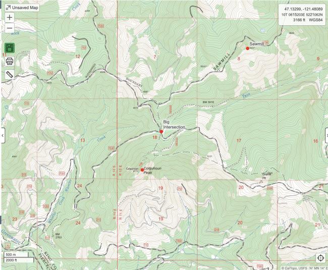
This was my 2nd winter activation of Colquhoun Peak. The name is pronounced 'Cal-hoon' (it's Scottish). The peak's name was suggested by the White River Recreation Association to honor member Carl Colquhoun who lost his life in 1931 while packing to this peak. In the summer it is an easy summit with a short hike.
It's been a few years since I have been able to access this area in the winter. Access in the winter is via the Pyramid Creek Sno-Park. To get to the Sno-park you take HWY 410 to NF 70, which is a bit south of the town of Greenwater, WA. The Sno-Park consists of an upper and lower park -- which park is open depends on snow condx. To access Colquhoun we need the lower Sno-Park to be open, and it hasn't been for the past couple of years.
We arrived at the lower park to find that the gate to the upper park was open, but the road was covered in snow and very icy. We decided to unload the snowmobiles at the lower park and ride them up the road. After a few miles on the road we turned off on NF 7030. This is the same way you get to Kelly Butte, which is a very popular hike. The snow wasn't deep but the road was very icy. There were a lot of lifted 4x4s playing all around.
We made it up to what we call the 'Big Intersection' (7030 and 7036 intersect) and decided to see if we could get up to Pechugh Peak (pronounced 'peek-you'. It means 'green' in Chinook). No one had been up the road yet, and we quickly got stopped by a huge snowdrift. We turned around and headed back toward Colquhoun. We were able to ride most of the way up the spur road to the Colquhoun trailhead. We were stopped by a downed tree about 200' short of the trailhead. Time to don our snowshoes!
The hike up to the summit was great - snow condx were decent and it wasn't too cold. It was cloudy but the sun was threatening to burn through. Once we made it on summit we quickly deployed HF and got to work. HF was in good shape - there was a contest going on 10 meters and it was wall-to-wall signals!
John K7JRO and Chris WX7EMT were en route to the summit of Mount Teneriffe and planning a short VHF activation, so were were hoping to catch them for an S2S. We had decent cell service so we could track their progress via John's Garmin InReach map. We could see they were close so we decided to hang out a while and try to catch them. Our waiting paid off as we were able to get them on 2m, and they were happy to get 2 QSOs instantly. By this time snow had started falling, and it was getting very wet and drippy on the summit. Time to go!
We decided to see if we could get to Sawmill Ridge, which was only a mile away. There was a 4x4 camp set up at the Big Intersection, and a bunch of people sitting around a campfire. There were tons of 4x4 tracks everywhere, so we had no trouble getting up the road. Eventually the 4x4 tracks stopped and we were following snowmobile tracks. We were able to make it over to Sawmill, but realized it was going to be dark soon and we didn't really have time for the hike. We spent some time (and energy!) getting one of the machines unstuck / turned around and then headed back. The ride back was uneventful - the road was a bit melted out but still enough snow for the machines.
Another fun day out playing radio in the snow!


