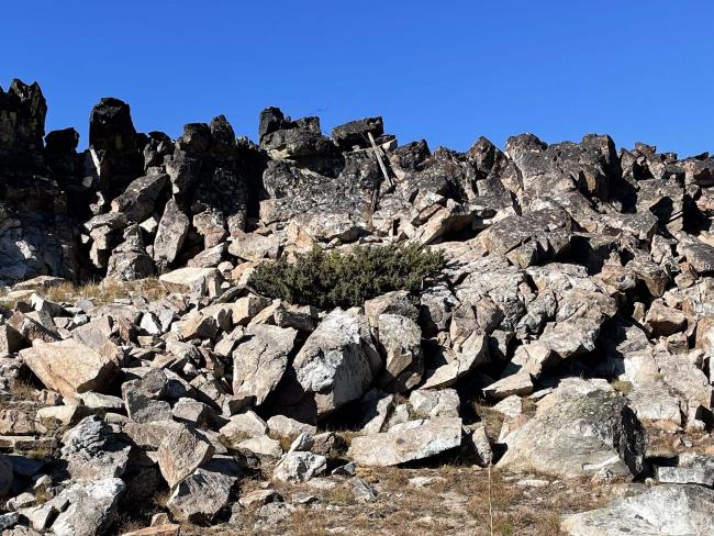
Horse Creek Butte doesn’t appear as classically defined buttes nor typical of buttes that characterize many Idaho and Montana landscapes. It has a highly fractured ridge of boulders capping the summit, but with little geological relief from the surrounding subalpine fir, and lodgepole and whitebark pine forest. The summit route has good views of the Frank Church River of No Return Wilderness Area, remote sections of the Salmon-Challis National Forest and large areas of burned forest.
The scramble/hike from the access road is through an old burn and up a constructed fuel break probably cleared for fire-fighting operations. An old logging road and trail indicated on my map were completely clogged with fallen snags and small trees so it’s just ‘pick your own route’ to get to the summit from the fuel break. The actual summit is a rib of highly fractured bedrock boulders, so I selected a ‘soft grassy area’ under the summit rock pile to operate. During the operation I was joined by a curious red fox that circled me. I wondered if the fox was investigating the CW sounds from my radio. The summit is a boulder pile but just off the summit are plenty of trees and snags for hanging antennas. An old wooden summit marker has fallen from its wired perch.
Many snags still exist in this landscape and carrying in your vehicle a chain or hand saw is highly recommended as well as being observant of hazardous snags while hiking, camping or summit operating.
Amazingly many of these remote summits along the ID/MT border and high elevations near the Salmon River do have cell phone coverage apparently from the Salmon Idaho area.
Non-Trail Miles: 2.2 round trip
Elevation Gain: 800’
Water: None
Bear Spray: Recommend for all ID/MT summits and hikes.
Camping: A few scattered openings without snag hazards exist along road #123 for dispersed camping.
Map: USFS Bitterroot National Forest
Directions: This remote country is accessible by a road system from the Salmon River or West Fork Bitterroot River Road system. One route from Darby MT is to travel south on highway #93 and turn south onto the West Fork Bitterroot River Road. Travel that road system beyond Painted Rocks Reservoir on county road #9600 and continue up on FS road #91 to Horse Creek Pass. From Horse Creek Pass travel approximately 2.5 miles southeast on FS #44 to the junction with Spring Creek Road FS#123 heading southwest. At this junction turn right and travel on Spring Creek Road #123 for approximately 11 miles. Find a good pullout and begin the hike to the summit. I selected a route through an old harvest unit to avoid lots of downfall. Then I intersected an old fire break following that and continuing up the southeast ridge to the summit.


