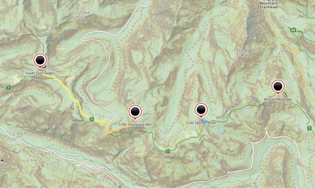
Four summits accessed via Klickitat Trail #7:
South Twin Sisters W7W/PL-020
5780 Shortwave Mountain W7W/PL-021
Cold Springs Butte W7W/PL-025
Mission Mountain W7W/PL-028
These four summits are located in the northern section of Gifford Pinchot National Forest, south of Randle, WA. They could be completed in two days with early start times and high endurance, but the average backpacker would probably feel better doing them over three days. The Klickitat #7 trail can be accessed from the west (FR 5508-024), north (FR 20), and east (Johnson Creek Rd). The trail is well-mainted, except for the section between Cold Springsn Butte and Mission Mountain, with many old deadfall over the trail—but the hiking is still easygoing.
I set out from Jackpot Lake (via FR 20) to the east, to complete South Twin Sister, then backtracked to the east to Shortwave Mountain, Cold Springs Butte, and Mission Mountain. There are many dispersed camping opportunities in the area of Jackpot Lake, including the unofficial trailhead parking on the north side of the road (46.46684, -121.69593), a large turnout with a small trail leading to trail #7 (46.46858, -121.70459), and a meadow with lots of huckeberries (46.46801, -121.70295).
Continuing east, camping areas are limited in some sections due to the steep hillside, especially on the south side of Shortwave Mtn: the saddle on the SE ridge offers some level and open areas (46.46087, -121.66755). I recommend camping near St. John Lake (46.46991, -121.61851); situated between Cold Springs Butte and Mission Mountain, it's a beautiful area, and a good place to replenish water stores.
If you're into mushrooming, choice boletes and matsutake abound along the entire trail.
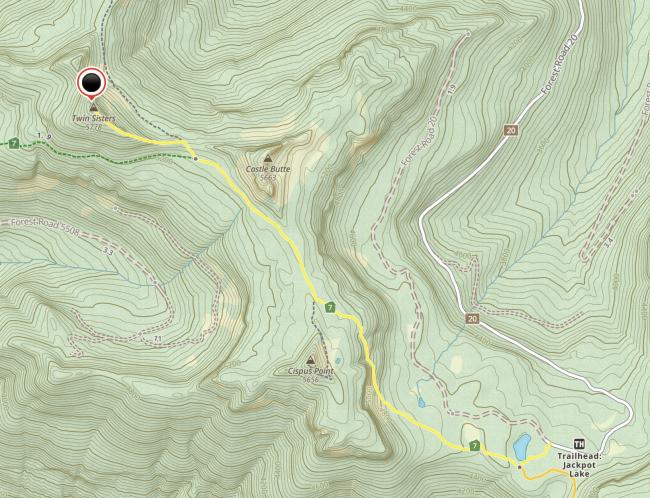
South Twin Sisters W7W/PL-020
Commence bushwhacking westward from the intersection of trail #7 and #128. Stay on the south side of the ridge to the north to avoid precarious exposed scrambling on loose chossy rocks with cliffs on the north side, and dangerously steep pumice scree slopes on the south side that may send you sliding uncontrollably down the slope (with cliffs in some places) if you slip or fall. I took the ridge up, but avoided it on the way down. If you choose to brave the ridge, bear in mind there's a 15' section of Class 4 climbing with a horrible landing if you fall (45° scree slope that terminates at a cliff). Don't consider the ridge unless you have significant experience rock climbing and have a keen sense of your abilities and limits. The hike is 2.77 miles, 1354' from Jackpot Lake.
The summit is rather small and forested, with small open areas, and just enough room for my 67' EFHW.
5780 Shortwave Mountain W7W/PL-021
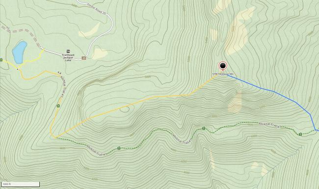
From Jackpot Lake, walk a liesurely 0.6 miles east along trail #7. Commence bushwhack at 46.46051, -121.69462, continuing NE to a beautiful large forested plateau. Keep to the east of the plateau to intercept the steep and sharp SW ridge to the summit. Distance: 0.9 miles. Ascent: 1000'. See orange line in image.
The summit consists of a large rock outcrop surrounded with scrub and loose sandy soil. The climb is precarious and exposed—not for the faint of heart.
If continuing east, a pleasant 0.6 mile bushwhack is possible along the SE ridge to intercept trail #7. See blue line in image.
Cold Springs Butte W7W/PL-025
Distance from Shortwave Mountain: 3.14 mi
Distance from Jackpot Lake: 4.3 mi
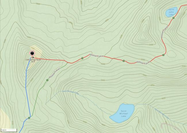
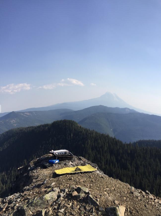
Continue east along trail #7 to a saddle at 46.46087, -121.63677. Continue with an easy bushwhack (orange line in image) 0.4 miles up the south ridge to a moderate section of scrambling up pumice scree and small rocky outcrops, for a total ascent of 300'. Traverse the narrow top ridge to a stone perch with just enough space to sit with a radio—this is one of the most stunning places I've ever sat. The ridge allows for various antennas setups.
If continuing east, a short easy 0.2 mile bushwhack is possible along the east ridge to intercept trail #7. See blue line in image.
Mission Mountain W7W/PL-028
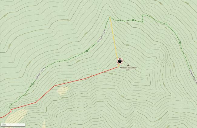
Continue east along trail #7 to a ridge at 46.47862, -121.58992. It's a steep but fairly open bushwhack to the top (orange line)—416' over 0.19 miles. You'll have plenty of room on the summit for setting up.


