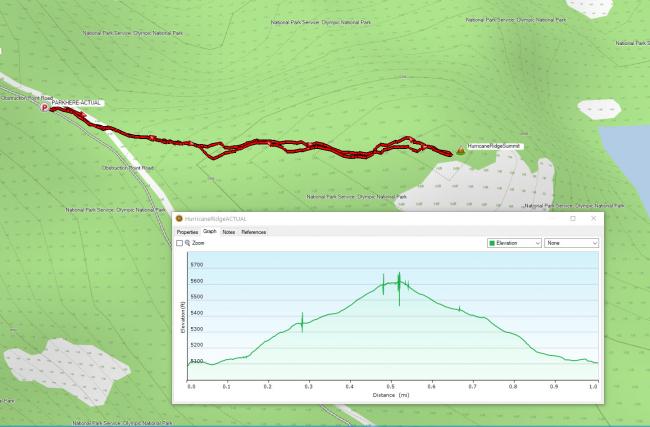
Summit 5645 (Hurricane Ridge) is in the Olympic National Park and accessible from a well-maintained forest service road named Obstruction Point Road. The road is not open all year, so check park conditions before you go. There is no established trail to this SOTA summit, but it is quite straightforward to follow the ridgeline to the summit and does not require bushwhacking.
It is a 20-mile drive from Port Angeles to the Hurricane Ridge Visitor Center, just before you get to the visitor center, take a sharp, nearly 180 degree left turn onto the dirt road. In 2020, there was a $30 fee for a motor vehicle to enter the park.
Once on Obstruction Point road, proceed to near N47.95711° W123.44502° and squeeze your vehicle on to the shoulder. Parking near here is possible as there are small turnouts along the way. I had a F-150 pickup truck and folded in my mirror and many vehicles, including a park ranger, got by me with no issues. It is a little challenging finding an entry point to get to the ridgeline from the road, but I scrambled up an elk trail that was established on some loose shale rock. Once you attain the ridgeline, just follow it approximately ½ mile to the summit.
There were many types of blooming wildflowers during my late July activation. I posted summit pictures on https://sotl.as/summits/W7W/NO-091.
Note about cellular coverage. I have ATT service, but was picking up stronger signals from Canada and ended getting charged international service since I have it set to automatically do that. Be careful of your cell phone settings!
Other SOTA summits off this road are: Eagle Point (http://www.pnwsota.org/blog/wa7jnj/2020-july-05/eagle-point-wa-july-2020) and Elk Mountain (http://www.pnwsota.org/blog/kj7eha/2020-august-04/elk-mountain-wa-july-2020)


