Pass Required at Trailhead
Trailhead parking or use of the trail requires a permit, pass or other for-pay document
Copper Creek Peak, WA September 2019

Summit
Our first snow of the year. I have done all the 8 point summits in the upper Dungeness area that I can get to with a day hike except this one. It seemed like a relatively easy one, 6 miles in with a half mile off trail to the summit. It was a good day for it. About a foot of power snow at the summit, but the ground under the snow wasn't frozen yet, so I could still get good traction without crampons.
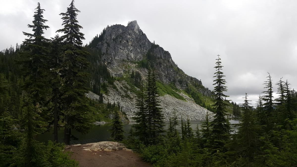
Eagle Cap, OR | September 2019

Summit
Eagle Cap is a gem of the Eagle Cap Wilderness of the Wallowa Mountains of Northeast Oregon. We approached from Lostine, Oregon for a total hike of about 20 miles (32km) round trip and 4,000 feet of gain (1220m). The trail is rocky in places and often steep. We enjoyed an overnight stay in the Lakes Basin with a side trip to Eagle Cap. Only some of the 19 ten-point summits in the Wallowas have an established trail - this peak is very approachable, despite the long hike required.
Long Mountain, Oregon | August 2019
Summit
Long Mountain has finally been activated! A 12 mile round trip for 1 point that costs $75 just to step foot past the logging road gate. A quiet hike with not a soul to disturb you while you take a long walk on the mostly exsposed logging roads. You will see wildlife, mostly birds, along with a stunning view of Mount Rainier, Mount St. Helens, and Mount Adams if the weather is clear.
Lichtenberg Mountain

Summit
I started from the Smithbrook Trail #1590 off of NFS Road #6700 which is just east of Steven's Pass on Hwy 2.
The trail goes up 1 mile to a junction with the Pacific Crest Trail. Turn left (Southbound) onto the PCT, continue about 2 miles and turn left down the Lake Valhalla access trail.
Devil's Peak, Oregon| July 2019
Summit
The Hike
Devil’s Peak is located in the Salmon Huckleberry Wilderness area on Mt. Hood. The summit has an altitude of 5045 feet. There is a decommissioned fire lookout at the top (which is available for camping). There are a variety of ways of getting up there. I chose to take the Cool Creek trail, which is short (3.7 miles) but very steep (3200 foot elevation gain). I hiked up here on July 20th, 2019. Also see http://www.pnwsota.org/node/177 for another approach.
Oregon Butte
Summit
Oregon Butte is the highest peak in the Blue Mountain Range of southeast Washington State. There is a lookout up there which should be staffed by early July. Beautiful spot, great views, and ample room to set up radio gear just about anywhere along the gently sloped ridge. I was there in late June and took advantage of the handy metal flagpole next to the lookout building to hoist up my antenna. Probably best to ask permission to do that when somebody official is around.
"3220 End Fed Hill" (Elbe Hills HP) 24 June 2019

Summit
This is an easy, accessible road walk in a state forest that includes just a little bit of a bushwhack into the activation zone. It is a perfect "second summit" if you are activating near Elbe, WA.
Etienne (K7ATN) emailed me a few weeks ahead saying he would be in S. Pierce County, a few miles from Eatonville on June 24. Hiking with Etienne is one of my favorite ways to activate, so we made plans to meet at Pack Forest for a pleasant hike to the Pack Forest high point (W7W/RS-068).
Trying to get up Prospect Ridge, 2019/05/27
Summit
After studying the map, I thought it was worth checking if the road that approaches the summit is accessible. I invited my family, and we drove up to check, and it definitely is not. We drove NF 23 to NF 2353, which proceeds past some campsites to the trailhead. There is a gate that is sometimes closed, but this doesn't really add a lot of effort to the trail. We got to NF2348, which turns into NF2365 and heads up the mountain, to find a berm had been constructed, decidedly closing the road. We made the decision to hike it anyway, and embarked.
Field Effect Mtn.

Summit
Field Effect Mtn in on Inland Empire Paper ground (IEP). Permit is required I would recommend going to there web site and read all the info to access the property. I started the track from Spirit Lake Id. The first 5 miles is paved then turns to dirt. At the trail head if the gate is open you can drive in if the gate is closed you can’t. The gate was closed so I had to take an ATV up close to the top then bushwhacked the rest of the way. If the gates are closed they will let you access by hiking, ATV or motorcycle. Great huckleberry picking spot.