This is an easily accessed peak in an area that's currently undergoing logging activity. We went up on a Saturday and had the place to ourselves. The peak and ridge is rocky with a few trees and lot's of deer and elk sign. There is a pleasant view mostly to the east. The activation area is large with plenty of room for a dipole antenna.
Activation Reports

Submitted by K7ZO on
Summit:
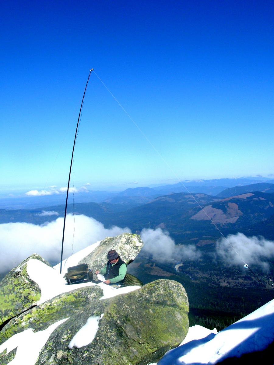
K7MK and I headed out on a somewhat blustery spring day for our second ever activation. With snow still on higher peaks and Forest Service roads not opening up until April 30th we headed to this nearby 1 pointer. Per Google Earth and other satellite imagery we knew there was a private home on the actual summit. But, it had been activated once before and the terrain looked like we should be able to find a spot in the activation zone somewhere to setup. Actually getting to this summit is a bit of a navigation challenge.

Submitted by K7ATN on
Summit:
Tiger Mountain is in about the middle of the Tiger Mountain State Forest southeast of Issaquah. Access is via a gravel forest road and you may want to use a GPS or track your mileage as any signs may not lead you clearly to the summit. You'll need a Washington State Discover Pass for this location.

Submitted by ND7PA on
Summit:
McCulloch Peak is another great peak to actiavte if you are in the Corvallis area. It is reached by taking OR Hwy 99W north from Corvallis and turning left about 3 miles from town on Lewisburg Rd. Take Lewisburg road 1.3 miles and bear right onto Sulfur Springs Road. Proceed to the top of Lewisburg Saddle and head back down the hill. Near the bottom of the hill, which is Soap Creek valley, the road will take a 180 degree right turn. This point is 3.9 miles from Hwy99. Stay straight turning onto the gravel road.

Submitted by N7KRN on
Summit:
Current trail conditions are packed snow and ice. Probably more to come in the next couple of days. We didn't bring our Yaktrax and paid the price by slipping and sliding all over the place. Our ascent took too long, and the more careful descent even longer.
Submitted by ND7PA on
Summit:
This is a continuation of a trip I took to W7O/CM-132 during which I also
went to Sand Mountain, W7O/CM-077. Proceed as mentioned in the other blog
entry for W7O/CM-132, but before reaching the Big Lake Campgrounds turn
off FS 2690 onto FS 810, the Old Santiam Wagon Road. Road 810 is open to
mountain-bikes and apparently from the signage is also an active OHV area.
Take road 810 about 3 miles (estimated) until a road leads off to the left
marked with a sign denoting the Sand Mountain Special Geological area. Take
Submitted by ND7PA on
Summit:
There is a small peak south of Big Lake and the Hoodoo Butte ski area that
has piqued my interest for some time. (Ah, bad pun) I was there during a warm
day in March. However, Big Lake road is closed beyond the Ray Benson snopark
until May. Therefore, I took my mountain bike and figured I could cover the
road mileage quickly and also ride over to Sand Mountain and get both peaks in
the same day.
Big Lake road is also National Forrest road NF 2090. It intersects US HWY 20
roughly at Santiam pass. Take Big Lake road past the entrance to Hoodoo Ski
Submitted by ND7PA on
Summit:
The summit near "Dimple Hill" (W7O/CC-118) in McDonald forest near Corvallis
is a nice first summit or a good summit if you are in the area but don't have
much time to spare. To get there, travel north about 4 miles on OR 99W from
Corvallis until Lewisburg Road crosses 99w at the "City Limits Store". Turn
left on Lewisburg Road and travel 1.3 miles where Sulfur Springs Road heads
off to the right. Take Sulfur Springs road for 1.5 miles to the Lewisburg
Saddle (at the top of the grade) where there is ample parking for the trailheads
Submitted by K7ZO on
Summit:
K7MK and I headed out to activate this summit as our first ever activation. K7MK has been assembling a SOTA capable station for the last 6 months or so. We have done a dry run or two in his back yard and even hauled it up to a non-SOTA summit back in February on a rare warm winter weekend afternoon. But, this was our first real activation.
Submitted by K7ATN on
Summit:
If you are headed from Portland to Lincoln City, this could be your activation on the way. Or the way back. It's a drive up on a decent dirt and gravel road with the potential for a nice view at the top.